


CHAGAI DISTRICT
| Chaghi/Chagai District | |
| — District — | |
|
| |
| Country | |
| Capital | |
| Established | 1896 |
|
|
|
| Area | |
| - Total | 50,545 km2 (19,515.5 sq mi) |
| Population (2005 Estimate) | |
| - Total | 250,000 |
| - Density | 4.95/km2 (12.8/sq mi) |
| Website | |
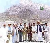
Chaghi/Chagai is the largest district of Pakistan and is located on the north west corner of Balochistan, Pakistan. It forms a triangular border with Afghanistan and Iran. Pakistan conducted a nuclear weapons test in 1998 at Ras Koh Hills Chagai District.
History
Chaghi/Chagai District was created in 1896. Nushki was the only sub division of the district with two tehsils, Nushki and Dalbandin. Naukundi sub tehsil was upgraded to tehsil in 1950. Chagai district was attached to Kalat District in 1957 but was detached after two years. The Police Department is still under the Superintendent of Police, Kalat. Dalbandin Tehsil was upgraded to Sub-Division on 1 February 1978. Taftan was created as sub tehsil in 1981. Chagai sub-tehsil was created with effect from 1 October 1985. The Assistant Political Agent Nushki remained sub-Divisional Magistrate of Nushki Sub Division till September 1989 when an independent post of Additional Political Agent was created for the district. Very little is known about the ancient history of Chagai.1998 Pakistan conducted their first ever nuclear weapons test at Ras Koh Hills Chagai District.
The earliest monuments are the ruins of terraced embankments. These are found at the foot of the Ras Koh hills; they are ascribed to the fire-worshippers, who are said to have been the inhabitants of this area more than two thousand years ago. The next traces of ancient history are the square shaped tombs in the western areas of the district, which are attributed by the local traditions to the Kianian dynasty of Iran. The remains of the ruined forts and karezes found in different parts of the district are assigned to the Arabs. These are also sometimes attributed to the Mughals and in any case indicate the presence of a richer civilisation than is now found among the Baloch and Brahui inhabitants of the district.
Administration
Chagai is administratively subdivided into the following tehsils:
- Chagai
- Saindak
- Nokundi
- Taftan
Nushki District
The newly formed Nushki District is administratively subdivided into:
- Dalbandin
- Nushki
Demography
According to the 1998 census the population of Chagai District was 202,562, along with approximately 53,000 Afghan refugees. The population of Chagai District was estimated to be over 250,000 in 2005. Over 99% of the people of the area are Muslims. The major Baloch tribes in the district are Sherzai, Mandazai, Mohammad Hassani, Muhammadzai, Al Ahmad Mustafa As Saud, Kashani, Sanjrani, Mengal, Notezai, Kubdani and Damanis near the Iranian border.
Topography
The district lies between 27°-55' to 29°-50' north latitudes and 60°-45' to 66°-22' east longitudes. It is located in the extreme west of Pakistan and comprises the belt which lies south of the Pakistan-Afghanistan boundary, from the Sarlath Hills on the east to Koh-i-Malik Siah on the west, with a length of about 576 kilometres and an average breadth of 80 kilometres. The district is bound on the north by the desert region of Afghanistan (which lies south of the Helmand River), on the east by the Sarlath hilly range and Kalat District, on the south by Kharan District and on the west by Iran. The northern boundary of the district, which separates it from Afghanistan, was demarcated in 1896 by a joint Afghan-British Commission. The western border with Iran was demarcated by a joint Pakistan-Iran Commission in 1959. The total area of the district is 50,545 km².


