


ABBOTTABAD

Abbottabad (Urdu: ایبٹ آباد) is a city located in Khyber Pukhtoonkhwa
History

The town of
Geography
The city is bounded at all four sides by the Sarban hills, from which residents and tourists can see breathtaking views of the region and city. The location of the city and the hills allows Abbottabad to experience pleasant weather in the summer and cold winters. Neighbouring districts areMansehra to the north, Muzaffarabad to the east, Haripur to the west and Rawalpindi to the south.Tarbela Dam is situated west of Abbottabad.
Topography
Abbottabad is situated in the
Climate
Abbottabad's climate is of extremes with mild temperatures during the spring and autumn months, humid temperatures during the months of June and July and below freezing temperatures during the winter. The temperature can rise as high as 30°C during the mid-summer months and can drop to below 0°C during the winter months. Snowfall is common in January while most rainfall occurs during the monsoon season stretching from May to August and can sometimes cause flooding.
Demographics
§ Languages
According to the 1998 Census of the 81,000 who resided in Abbottabad, Hindko was spoken by 94.26% of the population, followed by Potohari at 2.30%, Pashto at 2.22% and Urdu at 1.05%. Although the first language of most people in Abbottabad is Hindko, Urdu is understood and spoken fluently by majority of the residents and commonly used in the markets, offices and formal functions. English is widely used in business and education.
§ Ethnicity
The majority of the residents identify themselves as either Karlal, Jadoons, Sayeds, Malik Awan, Tanolis, Karlugh Turkss, Sheikhs, Sattis,Qazis, Sadozai, Kashmiris, Mughals, Rajputs, Qureshis, Utmanzai and Gujjars.
Government
Abbottabad is the headquarters of Hazara Division and Abbottabad District. The District Nazim, Commissioner, Inspector General and Forest Conservator all reside in Abbottabad. Abbottabad is divided into localities, towns, colonies and neighbourhoods.
Tourism

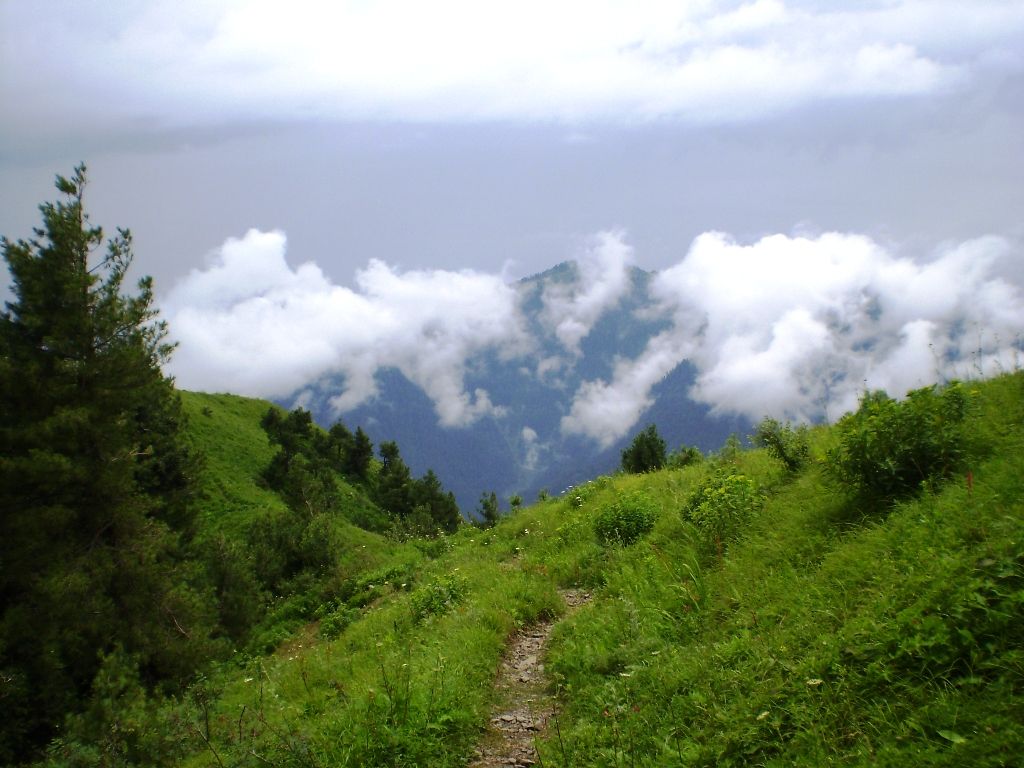
A view of Nathia Gali
Abbottabad has been attracting tourists to the city since the colonial era, as it is a major transit point to all major tourist regions of
Sports
§ Abasin Karate And Martial Arts Training Center
§ AMC-PCB Ground
§ Kunj Football Stadium
§ Nawanshehr Football Ground
§ Dhamtour Football Ground
§ Banda Lamba Football Ground
Education
Abbottabad attracts people from all over
Transportation
Roads
§ N-35 (also known as the Karakoram Highway)
§
§
§ College Road
§
§ Link Road
§
Transport
Abbottabad's main public transport consists of modified pickup vans Suzukis, which can accommodate anywhere from 8 to 13 people at one time. Taxis are also available as well as wagons which connect Abbottabad to the surrounding cities and towns (ex. Nathiagali, Sherwan,Dhamtour, Haripur, Mansehra) in the region. Abbottabad is also served by Daewoo Express and Niazi Express.
Rail
Pakistan Railways does not serve Abbottabad however a PR Reservation Office is located in Fawara Chowk in the city centre. The nearest railway station is located in Havalian, which is the last and most northern station on the Pakistan Railway network. The station is approximately thirty minutes drive south from Abbottabad city centre.


Love this place. Hopefully, one day I will visit here.
ReplyDeleteOne from India.
I'm glad to learn about this beautiful region. Would love to visit Abbottabad and use this city as a hub for hiking the mountains.
ReplyDeleteAbbottabad ! A place which truly reflects the image of heaven on Earth. The scenic beauties of Galliyat, the city itself , the nature of people etc are those which cannot be found any where in the world. I am a resident of Abbottabad and feel proud of being so. Nature is at its peak when Hazara Division and specifically Abbottabad is visited
ReplyDeleteI had visited once about 26 years ago and I do want to visit with my children again so they can admire the beauty that God has given us. It is remarkably beautiful. Please don't go abroad, just visit your own up country.
ReplyDelete