


Muzaffarabad


Muzaffarabad is the capital of Azad Jammu and Kashmir, Pakistan. It is located in Muzaffarabad District on the banks of the Jhelum and Neelum rivers. The district is bounded by Khyber-Pakhtunkhwa in the west, by the Kupwara and Baramulla districts of the Indian side of the Line of Control in the east, and the Neelum District of Azad Jammu and Kashmir in the north. According to the 1998 Census, the population of the district was 725,000, and according to a 1999 projection, the population had risen to almost 741,000. The district comprises three tehsils, and the city of Muzaffarabad serves as the cultural, legislative and financial capital of what is presently known as Azad Jammu and Kashmir.
Overview
The residents of Muzaffarabad are a highly literate and business orientated class maintaining close ties with the financial capitals of Northern Pakistan, primarily Rawalpindi and the NWFP. Muzaffarabad is a prime destination for further and higher education for the youth of Azad Jammu and Kashmir and also produces the elite class of Azad Jammu and Kashmir such as doctors, lawyers and businessmen. Rawalpindi is also a prime destination for further education and training.
Muzaffarabad is a centre of business once connected to Srinagar (Kashmir valley) and other north cities of which the culture can be seen to have had an effect. It must be noted that the entrance to the Kashmir valley faces northwards and passes westwardly through Neelum and down towards Muzaffarabad, where trade had flourished prior to the Kashmir dispute.
Location
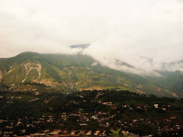
Muzaffarabad is situated at the confluence of the Jhelum and Neelum rivers. The city is 138 kilometres from Rawalpindi and Islamabad and about 76 kilometres from Abbottabad. Cradled by lofty mountains, Muzaffarabad reflects a blend of various cultures and languages. The main language is a form of Hindko and Pahari. The Neelum river plays a dominant role in the microclimate of Muzaffarabad which joins Jehlum River near Domail.
Railways
The closest railway stations are Rawalpindi in Pakistan and Baramulla in India. Jammu and Kashmir (India-Administered) Chief Minister Ghulam Nabi Azad said that he intended to extend the Kashmir rail line to Muzaffarabad, to facilitate movement of people and goods much easier across the LoC.
History
Early history
The original name of Muzaffarabad was Udabhanda.
| “ | Hieun tsang, the celebrated Buddhist pilgrim who is said to have visited the valley in 633 A.D mentions Pan-nu-tso i.e. modern day Punch, Ho-lo-she-pu-to i.e. modern day Rajauri. He entered | ” |
It is interesting to note that many places in Jammu and Kashmir on both sides of the line of control still maintain Hindu names.
Udabhanda was the capital of the Shahi dynasty. The Shahi (Devanagari शाही), also called Shahiya, dynasties ruled portions of the Kabul Valley (in eastern Afghanistan) and the old province of Gandhara (northern Pakistan and Kashmir) from the decline of the Kushan Empire in third century to the early ninth century. The kingdom was known as Kabul-shahan or Ratbel-shahan from (565 - 670 CE) when they had their capitals in Kapisa and Kabul, and later Udabhandapura (also known as Hund) for its new capital. The term Shahi is the title of the rulers, likely related to the Kushan form Shao or Persian form Shah and refers to a series of 60 rulers probably descended from the Kushans or Turks (Turshkas). They are split into two eras the Buddhist Turk-Shahis and the later Hindu-Shahis, with the changeover occurring sometime around 870.
Modern history
The name "Muzaffarabad" (meaning Muzaffar's Town) comes from the name of Sultan khan Muzaffar Khan (a Muslim ruler of Khandan-e-Bomba). After the 1948-49 war, Muzaffarabad was made the capital of Azad Jammu and Kashmir.
On October 8, 2005, the city was struck by an earthquake measuring a magnitude of 7.6 on the Richter Scale.
2005 Kashmir Earthquake
The city was the site of the epicentre of the 2005 Kashmir earthquake, which occurred on October 8, 2005 and had a magnitude of 7.6. The disaster destroyed 50% of the buildings in the city (including most of the official buildings) and is estimated to have killed up to 80,000 people in the Pakistani-controlled areas of Kashmir, alone.

As of 8 November, the Pakistani government's official death toll was 87,350. Some estimates put the death toll over 100,000.
Humanitarian aid reaches the devastated far-flung areas of Pakistan's Federally Administered Northern Areas (FANA).

Pakistani Soldiers carry tents away from a U.S. Army CH-47 Chinook helicopter that was there on October 19. The United States took part in the multinational effort to provide humanitarian assistance and support to Pakistan and Afghanistan following the devastating October 8 earthquake.

Heavy snowfall in the region around the epicentre, shown here in a January 6, 2006 NASA satellite image, hampered the relief efforts which began shortly after the earthquake struck.

Sangam Hotel in Muzaffarabad that was destroyed in the earthquake.
Sites of interest
Muzaffarabad Fort
There are two historical forts on opposite sides of the Neelum River, known as the Red Fort and the Black Fort.
The construction of the Red Fort was finally completed in 1646 by Sultan Muzaffar Khan, the founder of Muzaffarabad city. After the Mughalstook over Kashmir, the fort lost its importance. The Mughals were more interested in Kabul, Bukhara, and Badakhshan. During the period ofDurrani rule, however, the fort again once again assumed its importance.
Maharaja Gulab Singh and Rambir Singh, the Dogra rulers, reconstructed and extended the fort for their political and military operations. Towards the middle of 1947, the Dogra forces were forced to leave due to happenings of 1947 in the princely state of J&K.
The architecture of the fort shows that great experts in design and structure participated in its construction. It is surrounded on three sides by the Neelum River, formally known as the Kishenganga River. The northern part of the fort had terraces with steps leading to the bank of the river. The eastern side was well protected from the hazards of flood waters, but some parts on the north side have suffered damage. There used to be an inn at the entrance to the fort, but only traces of that structure remain now.
Other sites of interest
| § § § Mosque Assembly Secretariat § Kh. Khurshid Tomb § | § Subri (Langarpura) § § Allama Iqbal bridge § § Jallalabad Mosque | § President's house § Pearl continental Hotel § Nelum Hotel § Sungum Hotel |
Valleys
| § Pirchinassi § § | § § Chickar § Garhi Dopatta | § Nakkah § Bugna Kairabad § Darakoti, Nakar Fatot |
Villages
| § Buttdara § Buttal (Battal) § Nulha § Bandi § Devlian § Patika | § Sangri Mera § Dhmanchulh § Danna § Athmaqam § Sarra | § Ranjatta § Sri Janha § Kurhee § kherha § Khumanh § Lawat § Leswa § Sharda § Kel § Ashkot § Jura bandi |
Administration
The district is administratively subdivided into three tehsils.
§ Tehseel Muzaffarabad
§ Tehseel Athmakam
§ tehseel Ponch


No comments:
Post a Comment